Development Plan
The Development Plan serves as the guiding document for the 195 District's zoning and development requirements.
To view the development plan in full, open this PDF.
1.1 Creation of the District, Commission, and Plan of Development
- Special Economic Development District ("District")
Pursuant to R.I. Gen. Laws §42-64.14-5(b) and R.I. Gen. Laws §45-24.6-4 (the “SED Act”) any property owned by the I-195 Redevelopment District is designated as a special economic development district (referred to hereinafter as the “District”). Accordingly, only land owned now or formerly by the I-195 Redevelopment District is within the District (as its boundaries may be adjusted by the I-195 Redevelopment District Commission (the “Commission”)). No approval under this Development Plan for any development shall have any legal effect unless the Commission, in its sole discretion, determines to sell or ground lease land within the District to any such party on terms acceptable to the Commission.
- Adoption of Development Plan
Pursuant to the SED Act, the Commission adopts the following regulations as its plan of development for the District (the “Development Plan”) in accordance with the SED Act. The Development Plan shall be applicable to all construction in the District. In cases where the Development Plan does not provide necessary regulation and guidance, the City of Providence Zoning Ordinance shall be applied. Nothing in this Development Plan shall otherwise be construed to prevent the continuance of any building or improvement constructed prior to the adoption of the Development Plan.
- Regulation of Projects Following Completion
Following completion of a project on a parcel of land in the District (whether constructed under the Development Plan or prior to the adoption of the Development Plan), the subsequent use and alteration, including without limitation, its signage, shall be subject to the provisions of the Development Plan.
1.2 Purpose and Goals
- The Commission shall, at all times, further the purposes and goals of the District.
- All votes and determinations made by the Commission shall be based on a series of findings made by the Commission.
- Any final decision by the Commission will be based on a determination whether the overall effect of any proposal or a grant of any requested relief will further the goals and purposes of the District.
- The purposes of the District are to:
- Create a consolidated state-local-private sector partnership to plan, implement, administer, and oversee expedited redevelopment of the District.
- Authorize, provide for, and facilitate the consolidated and expedited exercise of development and redevelopment powers existing at the state and local levels as an instrumentality of the state with development tools greater than that of municipalities.
- Coordinate the development of education and enjoyment opportunities for the welfare of the general public.
- Protect existing development projects presently or formerly within the District from proposed uses and structures that may adversely affect the value and operations of such projects.
- Promote the commercial and economic development of the District such that the District attracts appropriate business, industry, tourism, trade, resources and investment.
- The goals of the District are to:
- Support the knowledge economy of the State of Rhode Island.
- Develop new economic opportunities for the State of Rhode Island.
- Enable the design and build out of an urban mixed-use neighborhood that complements Providence’s walkable downtown.
- Expand the downtown’s density along and adjacent to the I-95 corridor to maximize District land values sufficient to support the repayment of bonds issued in the creation of the District.
- Facilitate both direct and indirect support of the State of Rhode Island’s economy more generally.
- To foster economic development in the District and beyond and create an environment that encourages high-value users to build well-designed structures that enhance the value of surrounding neighborhoods and augment the sense of place.
1.3 Definitions
- Abutters
Abutting property shall mean property within 200’ of the pertinent property line.
- Deviation
A Deviation is a Waiver.
- Waiver
A Waiver is a R.I. Gen. Laws §45-24.6-8 Deviation which is a specific form of relief that may be granted where the enforcement of the regulations relating to setbacks, build-to lines, and other area and dimensional restrictions would preclude the full enjoyment by the owner of a permitted use and amount to more than a mere inconvenience. For the purposes of the application of the provisions of Section 2, which authorizes the granting of Waivers from the requirements thereof, such requirements shall be treated for all purposes as dimensional restrictions under R.I. Gen. Laws §45-24.6-8.
- Variance
A specific form of relief that may be granted pursuant to R.I. Gen. Laws §45-24.6-8 where, owing to special conditions, enforcement of the regulations would result in unnecessary hardship, where the variance will not be contrary to the public interest, and the spirit of the plan will be observed and substantial justice done.
- Concept Plan
The Concept Plan is comprised of a set of drawings that fully describe the spatial, physical, material, and expressive aspects of the development proposal.
- Final Plan
The Final Plan is comprised of a set of drawings that are equivalent to the architectural and site design/landscape design components of a Design Development drawing set. The Final Plan establishes and fixes the design of the project in the eyes of the Commission, District Staff, and the general public.
- Certificate of Approval
The Certificate of Final Plan Approval issued by the Commission pursuant to Section 1.5.8 approving an application for construction, erection, alteration, demolition, or use of a structure or land within the District, and pursuant to which a building permit may be issued.
- Certificate of Rejection
The document issued by the Commission rejecting an application for construction, erection, alteration, demolition, or use of a structure or land within the District.
- Certificate of Compliance
The document issued by the Commission certifying that a development project has complied with all of the Commission’s conditions and approvals and therefore the project is eligible for a Certificate of Occupancy.
- Special Exceptions
Uses or other modifications of the requirements of this Development Plan specifically authorized to be permitted by the Commission as provided for in the SED act.
- Temporary Use Permit
A permit that allows a use for a specified period of time but does not confer any property right or use right that runs with the land. Temporary Use Permits may be granted by the Executive Director. Temporary Use Permits may be revoked by the Executive Director or the Commission at any time without cause.
- Terms not Specifically Defined Herein
Terms not expressly defined herein shall have their plain and ordinary meaning except to the extent that they are expressly defined within the City of Providence Zoning Ordinance as determined by the Executive Director or Commission to be applicable.
1.4 Administration
- Delegated Authority
The Commission may delegate portions of the Commission’s authority to the Executive Director or the Executive Director’s subordinates so long as such delegation and any actions taken thereunder further the purposes and goals of the District. Otherwise, no action by any officer or agent of the Commission is binding upon the Commission unless and until the Commission either ratifies or has previously authorized the action at a public meeting.
- State Historic Preservation Officer
The Commission recognizes the authority of State Historic Preservation Officer (SHPO) as granted and limited pursuant to the 2000 Memorandum of Agreement by and between the Advisory Council on Historic Preservation, the Federal Highway Administration, and the Rhode Island State Historic Preservation Officer, with the Rhode Island Department of Transportation, John H. Chafee Blackstone River Valley National Heritage Corridor Commission, and City of Providence concurrent, as may be amended from time to time.
- Stakeholders
At the discretion of the Executive Director and the Commission Chairperson, the District may make use of Stakeholders such as the Providence Planning Department, the Rhode Island Department of Transportation, or any other such public agencies or nonprofit or community Stakeholders as may have knowledge or insight that could support the purposes and goals of the District.
1.5 Approval and Permitting Process
- Grants of Development Rights Generally
The Commission is empowered to grant, by way of a simple majority vote at a public meeting, any such planning and zoning Certificates of Approval or Rejection or other relief as may fall under the Commission’s powers which include, but are not limited to, powers and authority as may be expressly set forth or implied by other state law or regulation, so long as any such requested relief furthers the purposes and goals of the District as set forth in Section 1.2, Purposes and Goals. The Commission may condition any relief granted in any manner consistent with the District’s Purposes and Goals.
- Public Hearings
Pursuant to R.I. Gen. Laws §45-24.6-8(b), the Commission shall hold a hearing on any application for relief within a reasonable time and give (or cause to be given) public notice and due notice of the hearing to the parties in interest and property owners within two hundred feet (200’) of the affected property. At any hearing any party may appear in person or by agent or attorney.
- Comment during public hearings will be limited in topic to the particular presentation.
- In the sole discretion of the Commission Chairperson, the Commission may set a universal limit on the length of time that each member of the public may use for their comment.
- Specific Forms of Relief
Pursuant to R.I. Gen. Laws §45-24.6-8, the Commission, with or without conditions, may grant the following forms of relief upon conclusion of a noticed public hearing regarding said requested relief.
- Special Exception. The Commission may issue a Special Exception if the Commission finds that the Special Exception may be granted in furtherance of the Purposes and Goals of the District and where the use granted by Special Exception is reasonably necessary for the convenience or welfare of the public and does not substantially or permanently injure the value of neighboring property. The Commission may grant the following Special Exceptions:
- Surface Parking (see Section 2.4.B.6.e)
- Surface Parking (see Section 2.4.B.6.e)
- Variances: Any use or height Variance shall only be granted by Amendment of the Development Plan pursuant to R.I. Gen. Laws §45-24.6-6(c). Dimensional relief (other than specifically permitted by issuance of a Waiver under this Development Plan) shall be treated as a Variance for purposes of this Development Plan and such Variances may be granted where, owing to special conditions, enforcement of the regulations would result in unnecessary hardship, where the Variance will not be contrary to the public interest, and the spirit of the plan will be observed and substantial justice done because the granting of such Variance is supported by the purposes and goals of the District.
- Waivers: Waivers specifically authorized in this Development Plan may be granted as provided in R.I. Gen. Laws §45-24.6-8 and in accordance with the definition of Waiver set forth herein (Section 1.3.3).
- Amendment of the Development Plan: Pursuant to R.I. Gen. Laws §45-24.6-6(c), the Plan of Development may be amended only after a public hearing before the Commission, at which all interested parties have an opportunity to be heard. Notice of the time, place, nature, and purpose of the public hearing shall be given to all owners of real property within the bounds of the District and within two hundred feet (200’) of the perimeter thereof, by registered or certified mail at least seven (7) days before the date of the hearing, and by publication of notice in a newspaper of general circulation within the municipality at least once each week for three (3) successive weeks prior to the date of the hearing.
- Special Exception. The Commission may issue a Special Exception if the Commission finds that the Special Exception may be granted in furtherance of the Purposes and Goals of the District and where the use granted by Special Exception is reasonably necessary for the convenience or welfare of the public and does not substantially or permanently injure the value of neighboring property. The Commission may grant the following Special Exceptions:
- Administrative Review
The Executive Director is hereby empowered to make the following administrative determinations:
- Whether or not any proposal triggers a requirement for relief from the Commission, including but not limited to:
- Special Exceptions
- Variances
- Waivers
- Temporary Use Permits
- Amendment of the Development Plan
- Signage
- The grant or denial of a Temporary Use Permit.
- What materials and information are necessary for the Commission to review any proposal or requested relief, including but not limited to:
- What materials and information are necessary for application for Concept Plan approval.
- What materials and information are necessary for application for Final Plan approval.
- Whether or not to issue a Request for Proposal (RFP), Request for Qualifications (RFQ), or any other such competitive bidding procedure, and what responses, if any, are in fact responsive to the minimum requirements thereof.
- An administrative grant of a Certificate of Approval of proposed signage.
- Whether or not any proposal triggers a requirement for relief from the Commission, including but not limited to:
- Plan Approvals
The Commission shall review plans at a concept level, and following approval of a Concept Plan, the applicant may submit a Final Plan which shall be sufficient in detail to enable the Commission to conduct a comprehensive design review of the project. With respect to each of the plan filings, the Commission may take action on the applicable plan as detailed below. The Commission has established guidelines with the criteria required to be observed in the preparation and submission of the applicable plan. In each case the plan will be reviewed at one or more public meeting(s) at which the public will have the opportunity to comment.
- Concept Plan Review
The Commission will review complete Concept Plan applications at one or more public meeting(s). Such public meeting(s) shall include the opportunity for public comment. The Commission may vote on the following actions and require any of the following, with any conditions the Commission may deem fit:
- Reject: The Commission may deny the application with or without prejudice and issue a Certificate of Rejection.
- Remand: The Commission may require the applicant to undergo further administrative review.
- Approve: The Commission may approve the Concept Plan, with or without conditions, and issue a Concept Plan Approval. An approval of a Concept Plan shall include a grant of any of the following relief, as may be necessary and as requested at the time of Concept Plan application:
- Amendment of the Development Plan
- Special Exception(s)
- Waiver(s)
- Variance(s)
- Final Plan Review
The Commission will review complete Final Plan applications at one or more public meeting(s). Such public meeting(s) shall include the opportunity for public comment. At the conclusion of that public meeting(s), the Commission may vote on the following actions and require any of the following, with any conditions the Commission may deem fit:
- Reject: The Commission may deny the application with or without prejudice and issue a Certificate of Rejection.The Commission may deny the application with or without prejudice and issue a Certificate of Rejection.
- Remand: The Commission may require the applicant to undergo further administrative review or to reapply for Concept Plan approval or Final Plan approval.
- Approval: The Commission may approve the Final Plan with or without conditions. The Final Plan approval shall include any of the following, as may be necessary and as requested at the time of Final Plan application:
- Special Exception(s)
- Waiver(s)
- Variance(s)
- Pursuant to the MOA referenced in Section 1.4.2., the SHPO must review the Final Plan before approval can be granted.
- Certificate of Final Plan Approval
Once Final Plan approval has been granted, the applicant must submit construction documents and a construction management plan satisfactory to the Executive Director. The Commission shall then issue a Certificate of Final Plan Approval for the project documenting the special features of the approved Final Plan and containing such conditions determined by the Commission.
- Certificate of Compliance
Upon proof that the Applicant has built in accordance with the terms and conditions of the Certificate of Approval, the Commission shall issue a Certificate of Compliance. Such certificate may contain conditions.
- Certificate of Occupancy
No Certificate of Occupancy may be issued prior to the Commission issuing a Certificate of Compliance. Once a Certificate of Occupancy is issued, the property shall thereafter continue to be subject to the terms of the Development Plan.
1.6 Severability
If any clause, sentence, paragraph, section or part of these regulations shall be judged by any court of competent jurisdiction to be invalid, such judgment shall not affect, impair or invalidate the remainder thereof, but it shall be confined in its operation of the clause, sentence, paragraph, section or part directly involved in the controversy in which that judgment shall have been rendered.
2.0 Development Standards
2.1 Districts, Street Hierarchy, and View Corridors
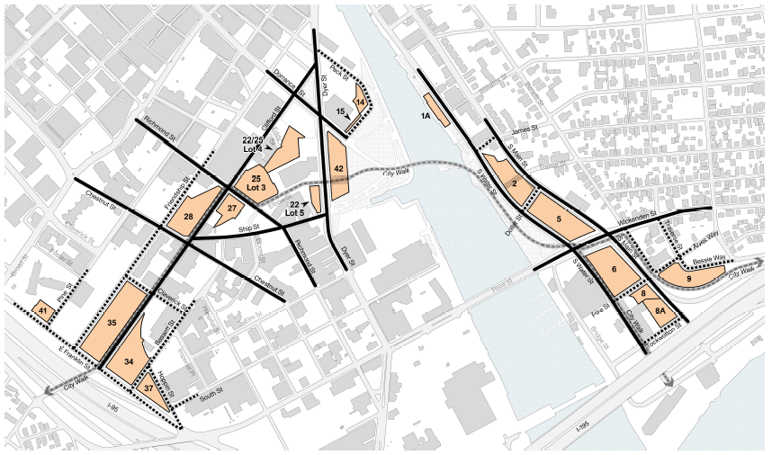
- Districts
In order to carry out the purpose and intent of this Development Plan, the land governed by this Development Plan is divided into the following Districts:
- West Side Highway District
-
The West Side Highway District includes Parcel 30, Parcel 34, Parcel 35, Parcel 37, and Parcel 41
-
The Development Plan aims to foster development in the West Side Highway District that enhances the economic vitality of Providence while promoting pedestrian activity at street level to reconnect Downtown and the Jewelry District. The West Side Highway District allows the greatest density in order to promote commercial and economic development that supports the knowledge economy of the State of Rhode Island and extends Providence’s downtown density to maximize District land values.
-
- West Side Riverfront District
-
The West Side Riverfront District includes Parcel 14, Parcel 15, Parcel 22 & 25 Lot 1, Parcel 22 Lot 2, Parcel 22 Lot 5, Parcel 22 & 25 Lot 4, Parcel 25 Lot 3, Parcel 27, Parcel 28, and Parcel 42.
-
The Development Plan aims to foster development in the West Side Riverfront District that provides a vibrant mix of uses to enhance the economic vitality of Providence and activate the park. Development will be organized around a series of new pedestrian and bicycle connections and linked open spaces that connect Downtown and the Jewelry District to each other and to the Providence riverfront. Uses have been restricted on some parcels in the West Side Riverfront District in order to promote commercial and economic development that supports the knowledge economy of the State of Rhode Island.
-
- East Side District
-
The East Side District includes Parcel 1A, Parcel 2, Parcel 5, Parcel 6, Parcel 8, Parcel 8A, and Lots 1 & 2 of Parcel 9.
-
The Development Plan aims to foster development in the East Side District that is pedestrian-friendly and mixed-use, activates the park, and creates a continuous urban fabric linking the Fox Point neighborhood to the Providence River.
-
- Open Space District
-
The Open Space District includes 195 District Park (Parcels P4 and P2) and Comley Square (Parcel P3).
-
The Development Plan aims to support the active use of the I-195 Redevelopment District parks by allowing uses that encourage activation and integrate the parks into the broader network of open space and cultural resources in Providence and Rhode Island.
-

- West Side Highway District
- Development Plan Map
The location and boundaries of land governed by this Development Plan are set forth in the Development Plan Map, as periodically amended. The Development Plan Map is incorporated into, and made an integral part of, this Development Plan. The I-195 Redevelopment District Executive Director is responsible for updating the Development Plan Map when it is amended by the Commission and shall provide such amended maps publicly on the District website.

- Street Hierarchy
-
Primary Streets include: South Main Street, South Water Street, Wickenden Street, Dyer Street, Dorrance Street, Richmond Street, Ship Street, Chestnut Street, and Clifford Street.
-
Secondary Streets include: James Street, Dollar Street, Pike Street, Tockwotten Street, Bessie Way, Alves Way, Peck Street, Claverick Street, Hoppin Street, South Street, East Franklin Street, Bassett Street, Friendship Street, and Pine Street.
-
City Walk is a pedestrian and bicycle priority corridor connecting neighborhoods from Roger Williams Park to India Point Park runs through the District. In the District, it follows Clifford Street from I-95 to Richmond Street, briefly running along Richmond Street to Elbow Street, then connecting through the park to the corner of South Water Street and Wickenden Street, where it branches, following South Water Street directly to India Point Park, and following a pathway between Parcel 9 and I-195 to the India Point Park overpass.

-
- View Corridors
View corridors are hereby established along Peck Street, Dorrance Street, and Ship Street to preserve important views to and from the Providence River. The three view corridors shall be uninterrupted physical extensions of the existing right-of-way width and geometry of said streets, and extend to the riverfront edge, as indicated in the map above. No permanant structures can be located such that they obstruct the view corridors. The following are allowed as of right within the view corridors:
- Temporary structures
- Public art
- Columns
- Canopies and Awnings
- Trees
- Landscaping or structures that are 3 feet or less
The view corridor streets are as follows:
- Peck Street, southeast from its intersection with Dyer Street to the Providence River.
- Dorrance Street, southeast from its intersection with Dyer Street to the Providence River.
- Ship Street, northeast from its intersection with Dyer Street to the Providence River.
2.2 Use
- VARIANCES
Variances for any use not permitted in this section shall not be granted without an Amendment to the Development Plan. The Commission shall, however, have the authority to determine that a use not specifically listed may be permitted upon the Commission’s determination that the proposed use is similar to one or more of the uses otherwise permitted and is consistent with the purposes and goals of the District and shall have no greater impact on Abutters than impacts comparable to an allowed use.
- ALLOWED USES
- The following uses are allowed in the West Side Highway, West Side Riverfront, and East Side Districts:
- Office
- Lab/Research and Development
- Hotel/Bed and Breakfast
- Educational Institution/Health Care Institution/Government
- Retail
- Restaurant/Bar/Specialty Food Service
- Brewery/Distillery/Winery
- Artisan Industrial/Industrial Design/Manufacturing uses with an accessory retail component, such as apparel manufacturing, millworking, food processing, etc.
- Live Entertainment Venue, provided that appropriate noise abatement is in place to minimize impacts on abutters
- Professional Services
- Personal Services
- Day Care
- Medical/Dental Office or Services
- Public Art/Arts Gallery/Arts Studio
- Live/Work Space combining residential with commercial, retail, or artisan industrial uses
- Community Center/Cultural Facility
- Multifamily Residential (rental and/or condominium) is allowed on all parcels except Parcel 22 & 25 Lot 1, Parcel 22 Lot 2, Parcel 25 Lot 3, Parcel 22 & 25 Lot 4, Parcel 22 Lot 5, and Parcel 27.
Mixed-use buildings are allowed and are strongly encouraged.
- The following uses are allowed in the Open Space District:
- Restaurant/Bar/Specialty Food Service
- Brewery/Distillery/Winery
- Live Entertainment Venue
- Public Art/Arts Gallery/Arts Studio
- Community Center/Cultural Facility
- Public amenities such as bathrooms
- Ancillary uses to support park operations and maintenance
- The following uses are allowed in the West Side Highway, West Side Riverfront, and East Side Districts:
- ALLOWED TEMPORARY/SEASONAL USES
- The Executive Director and Commission Chairperson have the authority to grant temporary use permits for uses including, but not limited to, the following:
- Outdoor Markets
- Outdoor Entertainment and Events
- Non-permanent Food and Beverage Establishments, including alcohol sales. All food and beverage (including alcohol) establishments shall be properly licensed by all applicable departments of the City of Providence and State of Rhode Island (including the Rhode Island Department of Health).
- Temporary Public Art Installations
- Outdoor seating for restaurant/bar/food service/brewery/distillery/winery is allowed and does not require a permit if it is located on private property. Outdoor seating that encroaches into the public right-of-way is subject to the authority of the City of Providence.
- The Executive Director and Commission Chairperson have the authority to grant temporary use permits for uses including, but not limited to, the following:
- GROUND FLOOR USES
Programming the ground floor of a building with active uses encourages walking and makes a neighborhood more vibrant. Active ground floor uses are encouraged to the maximum extent feasible, especially along Primary Streets.
- A portion of the ground floor along Primary Streets must be occupied with at least one of the following active uses:
- Retail
- Restaurant/Bar/Specialty Food Service
- Brewery/Distillery/Winery
- Artisan Industrial/Industrial Design/Manufacturing uses with an accessory retail component
- Live Entertainment Venue
- Professional Services
- Personal Services• Day Care
- Public Art/Arts Gallery/Arts Studio
- Live/Work Space combining residential with commercial, retail, or artisan industrial uses
- Community Center/Cultural Facility
-
Semi-active accessory uses, such as lobbies and common areas associated with office or residential uses, are also allowed.
-
Residential uses with individual unit entrances from the street are allowed on Secondary Streets, and on Primary Streets by Waiver. Live/work residential uses with individual unit entrances from the street are allowed on Primary and Secondary Streets.
-
Structured parking (and surface parking if a Special Exception is issued) shall be permitted as an accessory use. Parking is prohibited on the ground floor of a building within 20’ of a Primary Street (Figure 2.4-1 on page 24).
- A portion of the ground floor along Primary Streets must be occupied with at least one of the following active uses:
- SPECIAL EXCEPTION
Surface parking lots are prohibited except by Special Exception, which may be granted by a vote of the Commission. Surface parking lots are also permitted if constructed and maintained by the Commission.
- PROHIBITED USES
The following uses are expressly prohibited in all Districts:
- Billboard/Off-premise Advertising
- Halfway House
- Heavy Industrial uses
- Landfill/Incinerator/Waste Facility
- Prison/Correctional Institution/Detention Center
- Principal uses that require enclosed buildings that are not inhabited by people and have no windows
- Drive-through Establishments
- Automobile Dealerships or Service, Car Wash, Gas Station, Vehicle Rental (as principal use)
- Parking is prohibited in the Open Space District with the exception of temporary event-related vehicles
- Wholesale, Distribution, Warehouse, Self-storage, Open Air Storage
The following uses, except related accessory uses such as lobbies, vertical circulation and loading, are prohibited below the Ground Floor Design Flood Elevation (DFE-1):
- Any Residential Use
- Medical / Dental Offices or Services
- Educational Institution / Health Care Institution / Government
- Day Care
2.3 Dimensional Standards
| Table 2.3-1: Dimensional Standards | West Side Highway District | West Side Riverfront District | District East Side District | Open Space District |
|---|---|---|---|---|
| Minimum First Story Height | 15’ for non-residential uses 12’ for residential uses |
None | ||
| Minimum and Maximum Building Height | Parcels regulated individually; see Table 2.3-2 | 1 story | ||
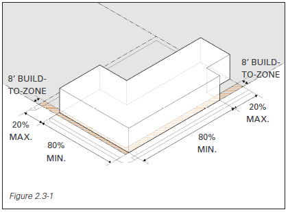
| Primary Street and Secondary Street Build-to-line | Build-to zone of 0’ to 8’, with minimum build-to percentage of 80% (Figure 2.3-1) | None | ||
| Interior Side Build-to-line | None | |||
| Rear Setback | None | |||
| Table 2.3-2: Minimum and Maximum Building Height | ||
|---|---|---|
| Parcel | Min. Height | Max. Height |
| 1A | 1 story | 6 stories |
| 2 | 2 stories | 6 stories |
| 5 | 2 stories | 6 stories |
| 6 | 2 stories | 6 stories |
| 8 | 2 stories | 6 stories |
| 8A | 2 stories | 130' |
| 9, Lots 1 & 2 | 2 stories | 6 stories |
| 14 | 3 stories | 130' |
| 15 | 1 story | 130' |
| 22/25, Lots 1-5 | 3 stories | 130' |
| 27 | 3 stories | 160' |
| 28 | 3 stories | 160' |
| 30 | 6 stories | 345' |
| 34 | 6 stories | 345' |
| 35 | 6 stories | 345' |
| 37 | 6 stories | 345' |
| 41 | 6 stories | 345' |
| 42 | 3 stories |
130’ by right; |
- Density variances for minimum and maximum height regulations may only be granted through an Amendment to the Development Plan. All other regulations in this section can be waived by a vote of the Commission.
- Proposals for Parcel 42 will be eligible for a density bonus allowing up to 166.5’ in building height if they include at least 20,000 gross square feet of Cultural or Civic Uses (as defined in Appendix 4.1 Glossary of Definitions), at least 8,000 of which must be on the ground floor. See Section 3 Parcel Specifications for additional detail.
- Build-to line requirements may be waived for the creation of courtyards, wider sidewalks, open space, vertical and horizontal circulation elements to reach the Ground Floor Design Flood Elevation (DFE-1), and/or outdoor seating in locations that contribute to public parks, City Walk, or other active pedestrian corridors.
-
For a vacant parcel of land, building height shall be measured from the average existing-grade elevation where the foundation of the structure is proposed or from the Ground Floor Design Flood Elevation (DFE-1), whichever is higher. Building height shall be measured to the top of the highest point of the proposed roof or structure. This distance shall exclude spires, chimneys, flag poles, and the like, as described in item 2 (Figure 2.3-2).
- The following structures or parts thereof are exempt from maximum height limitations, unless otherwise limited by any height restriction imposed by any airport authority or other similar federal, state, or local authority:
- Building appurtenances such as chimneys, parapet walls, skylights, steeples, flag poles, smokestacks, cooling towers, elevator bulkheads, fire towers, monuments, water towers, stacks, stage towers; scenery lofts, tanks, ornamental towers and spires; rooftop accessory structures; recreational facilities; necessary mechanical appurtenances; or penthouses to house mechanical appurtenances.
- Building appurtenances shall be eligible for this exemption only if they meet the following standards:
- The footprint of all building appurtenances shall not exceed 50% of the total floor area of the roof.
- All mechanical appurtenances or penthouses to house mechanical appurtenances roof equipment shall be set back from the edge of the roof a minimum distance of one foot for every two feet by which the equipment extends above the roof.
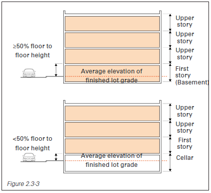
- A story is that portion of a building between the upper surface of any floor and the upper surface of the floor next above, including any portion of a building used for human occupancy between the topmost floor and the roof. A basement is counted as a story, but a cellar is not (Figure 2.3-3).
- The first story must meet the relevant minimum first story height (15’ for non-residential uses or 12’ for residential uses) for at least 75% of the frontage on Primary Streets.

2.4 Parking and Loading
Waivers to the standards in this section may be approved by a vote of the Commission, unless otherwise indicated.
- OFF-STREET VEHICLE PARKING REQUIREMENTS
There are no minimum vehicle parking requirements in any District.
- OFF-STREET VEHICLE PARKING DESIGN STANDARDS
The following standards apply to all off-street parking and parking structures constructed in any District.
- Electric vehicle charging stations shall be installed in minimum of 10% of total parking spaces provided.
- Access to surface parking and parking structures from Primary Streets is prohibited, with the following exceptions:
- When the parcel has no frontage on any Secondary Streets.
- When supported by evidence indicating impracticality due to site conditions.
- Where curb cuts are allowed, the following standards apply (Figure 2.4-1):
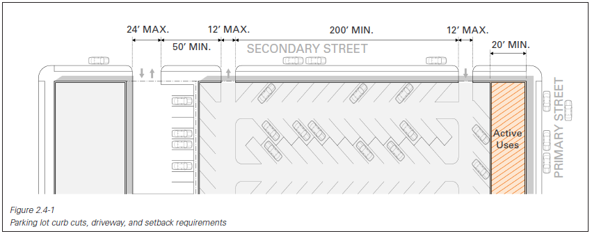
- The maximum width of a one-lane curb cut and drive-way for access to parking lots and parking structures is 12 feet. The minimum width of a two-lane curb cut and driveway for access to parking lots and parking structures is 20 feet and the maximum width is 24 feet.
- The minimum linear distance between any two curb cuts, including across multiple lots, is 50 feet (Figure 2.4-1).
- Each lot is limited to one curb cut per street frontage. Lots with more than 200 feet of frontage are allowed one additional curb cut every 200 feet (Figure 2.4-1).
- All curb cuts require approval of the City of Providence Department of Public Works.
- Ground floor parking structures shall be physically separated from Primary Streets by a linear distance of at least 20 feet (Figure 2.4-1).
- Parking structures shall be designed to minimize their visual impact on the public realm:
- Garage facades facing both Primary and Secondary Streets must be screened with architectural or landscape elements that provide texture and dimensionality.
- Garage structures and screening shall be designed to mask the visibility of vehicle headlights from the street and abutting buildings.
- Parking structure access ramps shall not be exposed on Primary Street facades.
- Surface parking is strongly discouraged, and is permitted only as a Special Exception by vote of the Commission and subject to the following conditions:
- Surface parking access is permitted only along Secondary Streets.
- Hydraulic lifts or other mechanical stackers may not be used in surface parking lots.
- The Commission may impose a time limit on the Special Exception that permits surface parking.
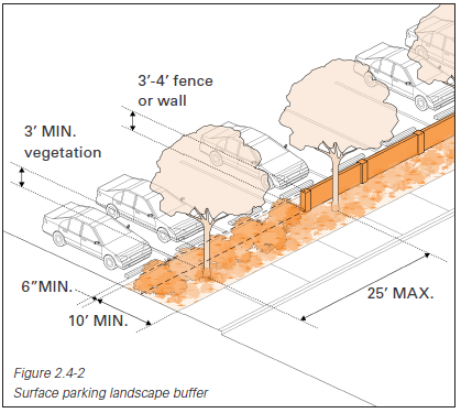
- Surface parking that is granted a Special Exception for a duration of one year or more are required to utilize low-impact-development practices consistent with City of Providence and state laws to treat and discharge stormwater, and shall be separated from the public right-of-way by a landscaped strip that adheres to the following design standards (Figure 2.4-2):
- The landscape strip shall run the full length of the surface parking perimeter along the right-of-way, excluding curb cuts.
- The landscape strip shall be a minimum of ten feet in depth. There shall be a minimum linear distance of six inches between wheel stops or curbs and the landscape strip to accommodate vehicle bumper overhang, which is not included in the minimum ten foot calculation.
- One shade tree shall be planted for every 25 feet of landscape strip length, spaced linearly.
- The landscape strip shall also be planted over a minimum of 60% of its length with shrubs, perennials, native grasses, and other planting types that screen a minimum of three feet in height.
- The use of stormwater management techniques such as rain gardens and bioswales is encouraged in landscape strips. Landscaped areas should be designed for the absorption of storm-water.
The foregoing limitations on surface parking shall not be applicable to any surface parking developed by the Commission.
- Developments with 20 or more off-street vehicular parking spaces must:
- Lease parking spaces in an “unbundled” fashion (meaning that parking is leased and priced independently from living and working spaces, rather than being bundled into core lease agreements);
- Allow for shared use by multiple uses and/or developments;
- Be publicly accessible with clear wayfinding, signage, and transparent market rate daily and hourly parking pricing; and
- Have infrastructure set up to allow for access card and payment.
- Electric vehicle charging stations shall be installed in minimum of 10% of total parking spaces provided.
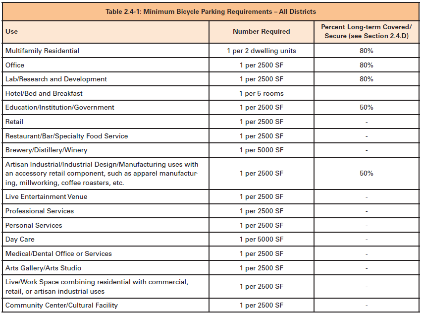
- OFF-STREET BICYCLE PARKING REQUIREMENTS
Table 2.4-1 details the minimum bicycle parking spaces required by use in each District. Where multiple uses with different parking requirements occupy the same structure or lot, the required number of bicycle parking spaces is the sum of the requirements for each use computed separately.
- BICYCLE PARKING DESIGN STANDARDS
- Location
- All bicycle parking areas shall be located such that they:
- Are visible from, accessible from, and convenient to building entrances and public right-of-ways;
- Do not interfere with normal pedestrian and vehicle traffic;
- Do not require bicyclists to travel over stairs to access parking; and
- Are accessible without requiring moving bikes or other items to access the space.
- Short-term bicycle parking spaces shall be located no more than 50 feet from the principal building entrance and at the same grade as the sidewalk or an accessible route. The property owner may also make suitable arrangements with the Department of Public Works to place required bicycle parking spaces in the public right-of-way. Parking in the public right-of-way shall be within 50 feet of the principal building entrance (Figure 2.4-3).
- Long-term bicycle parking spaces shall be located indoors, in weatherproof outdoor bicycle lockers, or fully covered with an overhang or covered walkway designed to protect bicycles from inclement weather.
- Long-term bicycle parking for residential uses may be provided in garages, storage rooms, and other resident-accessible, secure areas. Spaces within dwelling units or on balconies do not count toward bicycle parking requirements.
There are no minimum bicycle parking requirements for outdoor and/or temporary uses.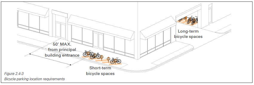
- All bicycle parking areas shall be located such that they:
- Design
- All bicycle spaces shall:
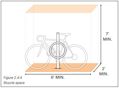
- Have a minimum dimension of two feet in width by six feet in length, with a minimum vertical clearance of seven feet (Figure 2.4-4);
- Be accessible without moving another bicycle.
- All bicycle racks shall be installed such that they:
- Are securely anchored to the ground or a structure;
- Support bicycles in an upright and stable position;
- Require minimal or no lifting of a bike;
- Accommodate standard U-shaped locking devices;
- Permit the bicycle frame and one wheel to be locked to the rack and provide two points of contact between the bicycle and rack in order to support the bicycle in a stable position (Figure 2.4-4).
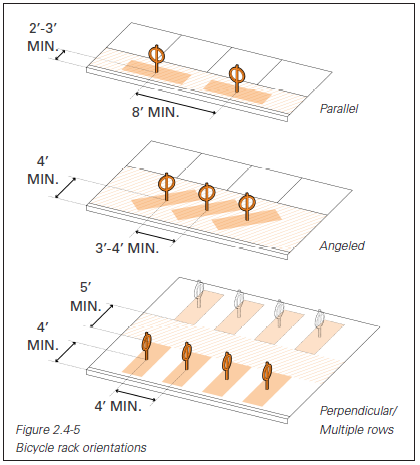
- The required space between two racks and between each rack and the curb varies by rack orientation. Where there is more than one row of bicycle racks, there shall be an aisle at least five feet wide between rows to allow for bicycle maneuvering (Figure 2.4-5).
- If required bicycle parking facilities are not visible from the street or principal building entrance, signs shall be posted indicating their location.
- The bicycle parking area shall be well-lit at all hours of the day and night.
- All bicycle spaces shall:
- Location
- LOADING
- Off-street loading spaces shall be provided for any use that distributes or receives materials or merchandise by trucks or other commercial vehicles.
- Access to loading docks and areas from Primary Streets is prohibited, with the following exceptions:
- When the lot has no frontage on any Secondary Streets.
- When supported by evidence indicating impracticality due to site conditions.
- Exterior loading docks are prohibited.
- Interior loading shall be screened from view by solid, non-transparent doors which shall remain closed when the loading dock is not in use. The doors used to screen the loading area shall be constructed of materials found else-where on the building and designed to be consistent with similar building elements, such as windows and doors, to reduce the industrial appearance of the loading area.
- Off-street loading space shall be designed with adequate means of vehicular access to a street or alley and in a manner that will minimize interference with traffic movement. The maximum width of a one-lane curb cut for driveway access to loading areas is 12 feet. The maximum width of a two-lane curb cut for driveway access to loading areas is 24 feet. The minimum linear distance between curb cuts is 50 feet. Wider curb cuts may be permitted by waiver if it is demonstrated that loading areas cannot be reasonably accessed given site conditions (Figure 2.4-1).
- Off-street loading spaces shall be provided for any use that distributes or receives materials or merchandise by trucks or other commercial vehicles.
2.5 Design Standards
Waivers to the standards in this section may be approved by a vote of the Commission, unless otherwise indicated.
- BUILDING DESIGN STANDARDS
- Massing and Facade Articulation
- For buildings more than 120 feet long, there must be a change in plane in the building facade above the ground floor every 100 feet, using architectural features such as notches, bays, offset facades, etc.
- The design of the building base shall be distinguished from the upper stories through the use of facade articulation, material changes, and/or similar architectural features.
- Three-dimensional facade elements, such as balconies and bay windows, are encouraged.
- Flat roofs shall include cornices, parapets, or similar architectural details to add articulation and create a shadow line at the top of the facade.
- For buildings 150 feet tall or more, a Wind Impact Study may be required.
- Fenestration
- Building facades shall not contain blank wall areas exceeding 25 linear feet, measured parallel to the street.
- For all non-residential ground floor uses:
- Facades shall provide areas of transparency equal to at least 70% of the wall area, between the height of one and 12 feet from the ground (Figure 2.5-1).
- The bottom of the window frame shall be no higher than two feet above the adjacent grade except where required to meet dry floodproofing requirements for facade elements below DFE-1.

- Where ground floor residential uses are allowed, the ground-floor facade of residential uses shall contain areas of transparency equal to at least 35% of the wall area of the ground-floor facade between the height of two feet and nine feet above grade. If tied to industry-recognized energy efficiency targets or certifications, a reduction in ground-floor residential transparency to at least 25% can be approved administratively, using the calculation method described above.
- Upper story facades shall provide areas of transparency equal to at least 35% of the wall area (Figure 2.5-1). If tied to industry-recognized energy efficiency targets or certifications, a reduction in upper story transparency to at least 25% can be approved administratively.
- The facade transparency percentage for each facade type (non-residential ground floor, residential ground floor, and upper story) is calculated and enforced in aggregate for all applicable building facades of a given type, rather than being calculated and enforced for each individual facade.
- Windows shall only be composed of clear or lightly tinted glass. Highly reflective window coatings are prohibited. Ground-floor and upper-story windows shall be composed of glass with a visible light transmittance (VLT) of at least 50% and a maximum exterior reflectivity of no more than 12%.
- Building Entry
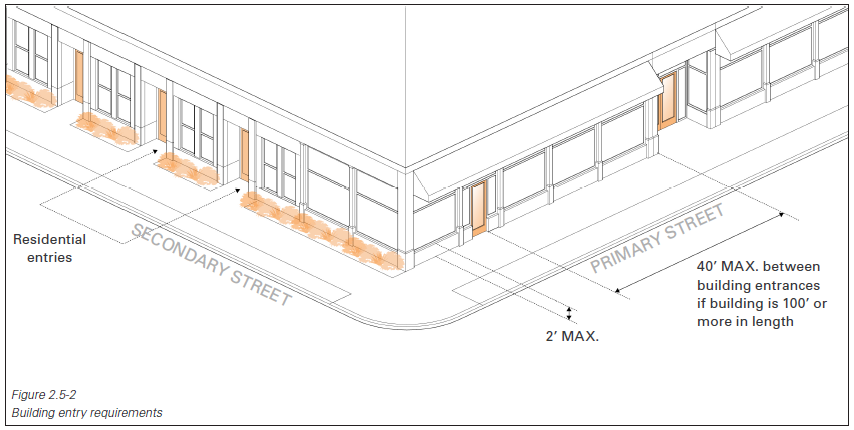
- For parcels with Primary Street frontage, buildings shall have their main entrance from a sidewalk on a Primary Street. For parcels without Primary Street frontage, buildings shall have their main entrance from a sidewalk on a Secondary Street.
- Entrances shall either be recessed from the plane of the facade or have a projecting Canopy, to provide adequate protection from the elements (Figure 2.5-2).
- Building facades that are 100 or more linear feet in length shall incorporate building entrances no more than every 40 linear feet of building frontage along the primary building frontage (Figure 2.5-2).
- For buildings with residential uses on the ground floor, individual unit entrances from the public right-of-way are required (Figure 2.5-2).
- Awnings (as defined in Section 4.1)
- Awnings shall be variations on the shed form.
- Use of one continuous awning across more than one building is prohibited.
- Awnings shall be constructed of metal, canvas, or fire-resistant acrylic. Plastic and vinyl are prohibited.
- Back-lit, dome, and waterfall awnings are prohibited.
- Awnings may project up to eight feet into the public right-of-way. Refer to Section 2.5.B.2 Encroachments into the Public Right-of-Way Not for Habitation for additional detail.
- All Awnings shall maintain a minimum vertical clearance of eight feet and the uppermost edge of the Awning shall sit below the second floor windowsill.
- Canopies and Marquees (as defined in Section 4.1)
- Canopies and Marquees shall be supported solely by the building to which they are attached. No exterior columns or posts are permitted as supports.
- The roof of a Canopy or Marquee shall not be used for any purpose other than to form and constitute a roof and shall be constructed of noncombustible material.
- Water from the roof of a Canopy or Marquee shall not drain, drip or flow onto the surface of a public right-of-way. Sufficient downspouts, drains, and gutters shall be installed as part of each Marquee to prevent water from the roof of the Canopy or Marquee from flowing onto the surface of a public right-of-way.
- Canopies or Marquees shall be erected over a building entrance and are limited to the width of the building entrance, plus a maximum of five additional feet on each side of the entrance doors covered by the Canopy or Marquee.
- All Canopies and Marquees shall maintain a minimum vertical clearance of eight feet and the roof of the Canopy or Marquee structure shall be erected below the second floor window sill.
- Marquees may encroach into the public right-of-way up to two feet from the curb line. Refer to Section 2.5.B Encroachments into the Public Right-of-Way Not for Habitation for additional detail.
- Canopies may project up to eight feet into the public right-of-way. Refer to Section 2.5.B Encroachments into the Public Right-of-Way Not for Habitation for additional detail.
- Use of one continuous Canopy or Marquee across more than one building is prohibited.
- Roof
- White roofs, which reflect solar energy to reduce heat transfer to the building, are required for any area of the roof not used for habitable space, plantings, or mechanical equipment.
- Habitable and non-habitable green roofs, which are planted with vegetation, are encouraged.
- Blue roofs, which enable stormwater to be captured and gradually discharged, are encouraged.
- Roof-mounted solar panels and wind turbines are permitted, subject to the design standards detailed in sections 2.5.C.5, 2.5.C.6, and 2.5.C.7.
- Mechanical Equipment
- Building-mounted mechanical and/or electrical equipment such as louvers, exhaust equipment, ducts, alarm devices, cable boxes, utility meters, etc. shall not be mounted on a Primary Street facade.
- Ground-mounted mechanical equipment is prohibited along Primary Streets.
- Ground-mounted mechanical equipment located along a Secondary Street shall be located a minimum of 20 feet from the lot line along a Primary Street (Figure 2.5-3).
- Roof-mounted mechanical equipment shall be set back from the edge of the roof a minimum distance of one foot for every two feet by which the equipment extends above the roof (Figure 2.5-3).
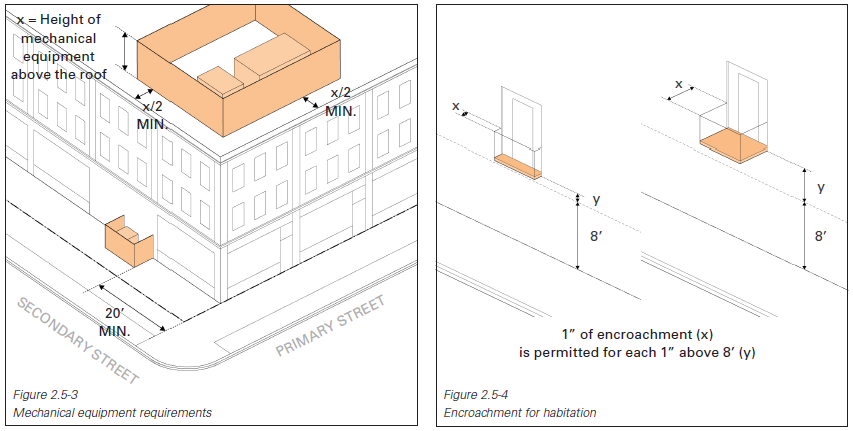
- Ground-mounted mechanical equipment shall be screened to limit visibility by a pedestrian from adjacent public right-of-ways and pedestrian pathways. The screening shall complement the design of the building through the use of appropriate plantings and complementary materials, colors, finishes, and architectural details (Figure 2.5-3).
- Roof-mounted mechanical equipment shall be screened to be limit visibility by a pedestrian from adjacent public right-of-ways. The screening shall complement the design of the building through the use of complementary materials, colors, finishes, and architectural details (Figure 2.5-3).
- Massing and Facade Articulation
- ENCROACHMENTS INTO THE PUBLIC RIGHT-OF-WAY
Certain architectural features and uses are permitted to encroach into the public right-of-way by an encroachment permit granted by the City of Providence. Two types of encroachments are permitted into the public right-of-way as described in this section.
- Encroachment for Habitation
- An encroachment for habitation is any construction that projects from a building over, onto, or under a public right-of-way that is designed for and can accommodate human or other habitation including, but not limited to, balconies, bay windows, arcades, overhangs, basement vaults, subterranean parking garages, and the like, whether supported by the ground or not.
- An encroachment for habitation includes structures and similar elements for ancillary uses including outdoor dining, temporary outdoor sales, temporary outdoor entertainment, temporary mobile food sales, and live entertainment when such uses are conducted on the public right-of-way.
- Where the vertical clearance above grade to projecting windows and balconies is more than eight feet, one inch of encroachment is permitted for each additional one inch of vertical clearance above eight feet, up to a maximum of four feet of encroachment (Figure 2.5-4).
- Encroachment Not for Habitation
- An encroachment not for habitation is any construction that projects from a building over, onto, or under a public right-of-way that is not designed for and cannot accommodate human or other habitation including, but not limited to, Awnings, Canopies, Marquees, signs, architectural embellishments, foundations, wheelchair ramps, stairs, and the like, whether supported by the ground or not.
- An encroachment not for habitation that encroaches over, onto, or under a public right-of-way is limited as follows:
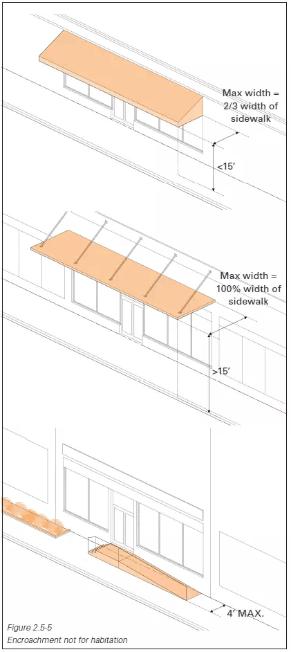
- Awnings, Canopies, and signs with less than 15 feet vertical clearance above the sidewalk may extend into or occupy up to two-thirds of the width of the sidewalk measured from the lot line. Awnings, Canopies, and signs with 15 feet or more vertical clearance above the sidewalk may extend into or occupy up to 100% of the width of the sidewalk (Figure 2.5-5).
- All other encroachments may extend up to four feet into the right-of-way, but in no case may extend farther than the curb line (Figure 2.5-5).
- Encroachment for Habitation
- ACCESSORY STRUCTURES AND USES
- Outdoor Dining
- Outdoor dining shall not interfere with any pedestrian access or parking spaces and aisles.
- Outdoor dining areas shall be located on private property unless an encroachment permit is granted by the City of Providence to allow outdoor dining in the public right-of-way.
- An outdoor dining area for an establishment shall be as continuous as possible by locating the outdoor dining area in a single portion of an establishment’s frontage.
- Outdoor Sales and Display
- Retail goods establishments and similar retail uses are permitted to have accessory outdoor sales and display of merchandise. However, outdoor storage of goods not offered for sale by the establishment is prohibited.
- Any outdoor display shall be located on the same lot as the principal use. Outdoor display may be located on the adjoining sidewalk only with the appropriate City of Providence permits and/or licenses.
- The goods may only be displayed when the use is open for business and shall be removed at the end of each business day
- Public Art
- Proposals for public art on private property within the District shall be approved as part of Concept and Final Plan Approval or subsequently by the Executive Director. Proposals of a significant or permanent nature or in a prominent location may be recommended for a vote by the Commission. Proposals for public art within the public right-of-way are subject to the authority of the City of Providence.
- Proposals for public art on private property within the District shall be approved as part of Concept and Final Plan Approval or subsequently by the Executive Director. Proposals of a significant or permanent nature or in a prominent location may be recommended for a vote by the Commission. Proposals for public art within the public right-of-way are subject to the authority of the City of Providence.
- Refuse and Recycling Container
- Refuse and recycling containers are prohibited along Primary Streets.
- All refuse and recycling containers shall be fully enclosed on three sides by a solid fence, wall, or wall of the principal building to a minimum of six feet and a maximum of eight feet in height. The enclosure shall have a solid gate.
- Rooftop Accessory Structure
- Accessory structures and rooftop features, such as green roofs, rooftop decks, rooftop gardens, storm-water detention systems, and similar accessory structures and uses are permitted on rooftops. Such structures are excluded from the calculation of height.
- The roof shall contain sufficient space for future necessary operational installations such as mechanical equipment.
- Solar Energy System (Accessory Use)
- Solar panels may be building-mounted or, if a Special Exception is granted for a parking lot, solar panels may be constructed as a freestanding canopy above a parking lot.
- Solar panels shall be placed so that concentrated solar radiation or glare is not directed onto nearby properties or roadways.
- A building-mounted system may be mounted on the roof or wall of a principal building or accessory structure, subject to the following restrictions:
- On pitched roof buildings, solar panels must be at the same slope as the roof and offset a maximum of six inches.
- On flat roofed buildings, the solar panel system is limited to 15 feet above the height of such structure. Roof-mounted solar energy systems are excluded from the calculation of building height.
- If visible from the right-of-way of any Primary Street abutting the property, the solar panels shall be integrated into the structure as an architectural feature.
- Solar panels may be co-located on structures such as light poles.
- Wind Energy System (Accessory Use)
- Wind turbines may be designed as either vertical or horizontal axis turbines with or without exposed blades, including designs that combine elements of the different types of turbines
- Ground-mounted turbines are prohibited.
- Roof-mounted wind turbines are allowed, subject to the following restrictions:
- Roof-mounted wind turbines are limited to a maximum of 15 feet above the rooftop or parapet, whichever is greater. Roof-mounted wind turbines are excluded from the calculation of building height.
- Maximum height is the total height of the turbine system, including the tower and the maximum vertical height of the turbine blades. Maximum height therefore is calculated measuring the length of a blade at maximum vertical rotation to the base of the tower.
- Roof-mounted wind turbines shall be set back a minimum of 20 feet from all building walls, and shall be screened from view to the extent possible.
- Shadow flicker shall be confined to the roof of the structure. This standard may be waived if no negative impacts result from a greater area of shadow flicker.
- Outdoor Dining
2.6 Flood Resilience Standards
Waivers to the standards in this section may be approved by a vote of the Commission, unless otherwise indicated.
- GOALS
The goal of flood resilience standards in the District is to balance best practices for long-term flood protection with reasonable development feasibility and public realm benefit. Flood resilience standards are specific to the District’s unique geography and hydrology, and include measures to protect new structures from both the immediate threats of riverine and tidal flooding, as well as longer-term risk associated with storm surges. The District sits in a FEMA X zone and is not subject to FEMA flood requirements, as it is protected by a hurricane barrier. Requirements set forth in this document reflect risks from existing riverine flooding events and future sea level rise, neither of which are currently accounted for in FEMA regulations.
Two design flood elevations have been identified to address these varied conditions. - GROUND-FLOOR DESIGN FLOOD ELEVATION (DFE-1)
DFE-1 is intended to elevate new development above the impacts of current riverine and future tidal flood risk from which the Fox Point Hurricane Barrier does not provide protection.
- Required Minimum Elevation
DFE-1 shall be at a minimum elevation of 9.3’ NAVD88, which is the highest recorded level of precipitation-related flooding in the Providence River. - Below Minimum Elevation
Where existing grades are lower than DFE-1, the preferred approach is to locate vertical circulation elements, such as stairs and ramps, external to the building so that all internal uses are above DFE-1. External circulation elements should contribute to the activation of the public realm; at a minimum they should be accesible and well-landscaped. On dimensionally constrained sites where external vertical circulation may not be feasible or practical, ground-floor uses below DFE-1 shall be dry floodproofed. Any occupiable space below DFE-1 must be dry floodproofed except low-occupancy service spaces such as loading and parking, which must be wet floodproofed at a minimum. Deployable flood barriers are permitted as part of a dry floodproofing approach. Any electrical switches and wiring located in an elevator hoistway below DFE-1 must be dry floodproofed. - Uses
In no case shall the following uses be permitted below DFE-1:
- Residential,
- day care,
- medical and health care,
- educational, or
- government.
- One-Story Structures
One-story structures may locate critical mechanical and electrical building systems at grade, but not below DFE-1.
- Required Minimum Elevation
- SECOND-FLOOR DESIGN FLOOD ELEVATION (DFE-2)
DFE-2 is intended to provide longer-term resilience in multi-story buildings in the event that the hurricane barrier is inoperable or overtopped by a future storm surge exacerbated by sea level rise.
- Required Minimum Elevation
DFE-2 establishes a benchmark for the protection and continued occupancy of upper stories and shall be at a minimum elevation of 24.5’ NAVD88. - Critical Systems
Critical mechanical and electrical systems in multi-story buildings are not permitted to be located at elevations below DFE-2. - Below Minimum Elevation
The use of flood-resistant materials and provisions for flood vents or their future installation below DFE-2 is encouraged.
- Required Minimum Elevation
- APPLICABILITY
DFE-2 applies to the entire District. DFE-1 applies only to parcels that are partially or fully below the DFE-1 threshold. Parcels that may be fully or partially below the DFE-1 threshold are as follows:
- Parcel 1a
- Parcel 2
- Parcel 14
- Parcel 15
- Parcels 22 & 25 Lot 1
- Parcel 22 Lot 2
- Parcel 25 Lot 3
- Parcel 22 & 25 Lot 4
- Parcel 22 Lot 5
- Parcel 42
- DEFINITIONS
See Section 4.4 for definitions and examples of wet and dry floodproofing, as well as other emerging best practices for building resilience.

2.7 Site Improvements
Waivers to the standards in this section may be approved by a vote of the Commission, unless otherwise indicated.
- EXTERIOR LIGHTING
In order to ensure that impacts of exterior lighting on adjacent properties are controlled, exterior lighting shall adhere to the following requirements:
- Maximum Lighting Regulations
- The maximum allowable light level at any lot line is one foot-candle.
- No glare onto adjacent properties is permitted.
- Luminaire Standards
- All luminaires shall be designed as cut off luminaires with a cut off angle of 75 degrees or less, subject to the following standards:
- The maximum total height of a cut off luminaire, either freestanding or attached to a structure, shall be 18 feet. The total height of a luminaire is measured to the top of the pole or luminaire, whichever is higher, from grade (Figure 2.7-1).
- A cut off luminaire shall be designed to completely shield the light source from an observer three and one-half feet above the ground at any point along an abutting lot line (Figure 2.7-1).

- Flickering or flashing lights are prohibited.
- Searchlights, laser source lights, or any similar high intensity lights are prohibited.
- Electrical conduit and junction boxes shall be located so as to minimize or, if possible, eliminate their visibility from the public right-of-way.
- All luminaires shall be designed as cut off luminaires with a cut off angle of 75 degrees or less, subject to the following standards:
- Maximum Lighting Regulations
- FENCES AND WALLS
- Fences and walls shall not exceed six feet in height. The combined height of any fence and wall cannot be more than six feet, with the exception of enclosures for refuse and recycling containers, which may be up to eight feet in height.
- No fence or wall within five feet of the lot line along a Primary Street, or a Secondary Street if there is no Primary Street frontage, shall exceed 36 inches in height.
- Height is measured from the adjacent finished grade to the highest point, with the exception that decorative posts of a fence or wall may exceed the maximum height by six inches.
- The bottom rail of a fence shall be installed a maximum vertical distance of six inches above the adjacent finished grade for the entire length of the fence.
- Barbed wire and razor wire fences are prohibited.
- Permanent chain link fences are prohibited. Temporary chain link fencing is permissible only during construction.
- Fences and walls shall not exceed six feet in height. The combined height of any fence and wall cannot be more than six feet, with the exception of enclosures for refuse and recycling containers, which may be up to eight feet in height.
- LANDSCAPING REQUIREMENTS
- Landscape Design Standards
- Selection of Plant Materials: All plant materials shall meet American Association of Nurserymen (AAN) standards for minimum acceptable form, quality, and size for species selected, and capable to withstand the seasonal temperature variations of Rhode Island, as well as the individual site micro-climate. The use of species native or naturalized to Rhode Island is encouraged. Where appropriate, the use of drought and salt tolerant plant material is preferred.
- Installation of Plant Materials: All landscape materials shall be installed in accordance with the current planting procedures established by the AAN.
- Minimum Planting Sizes:
- Shade trees shall have a minimum trunk size of two inches in tree caliper at planting.
- Evergreens trees shall have a minimum height of six feet at planting.
- Single stem ornamental trees shall have a minimum trunk size of two inches in tree caliper at planting. Multiple stem ornamental trees shall have a minimum height of eight feet at planting.
- Large deciduous and evergreen shrubs, which reach five or more feet in height at maturity, shall have minimum height of three feet at installation. Small deciduous and evergreen shrubs, which are those typically maintained at up to 30 inches in height, shall have a minimum height of 18 inches at installation.
- Species Diversity: Diversity in plant material is required for visual interest and to reduce the risk of losing a large population of plants due to disease.
- Tree Protection during Construction: All precautions shall be undertaken to prevent construction damage to existing trees, as described in the City of Providence Tree Ordinance. Protection includes prevention of injury to the trunk, branches, and root systems. No person may create a trench through the root system of an existing tree, expose the roots to the air overnight without a method for maintaining moisture, change the soil grade within the dripline of the tree, or cause soil compaction with the use of vehicles, machinery, or other method. The root systems of trees on adjacent lots shall also be protected.
- On-site Landscaping and Required Trees: All portions of a lot not covered by structures or paved surfaces shall be landscaped with trees, shrubbery, grass, live groundcover, and other plantings. The landscape design may also include the use of stone, mulch beds, or other previous landscaping materials (this excludes previous pavement).
- Landscape Design Standards
2.8 Signs
Waivers to the standards in this section may be approved by a vote of the Commission, unless otherwise indicated. Within the Open Space District, waivers to the standards in this section may be approved by the Executive Director.
- SIGN DESIGN STANDARDS
- All signs, including window signs, are subject to approval by the Executive Director.
- All signs should be proportional to the architecture they relate to and should complement the scale and features of the architecture. The scale, orientation, and design of all signs should take into consideration their visibility and the distance, direction, and speed of travel of their primary and secondary audiences.
- All signs placed within a public right-of-way require a City of Providence right-of-way encroachment permit.
- Permanent signs shall be made of metal, painted wood, or other high-quality, durable materials.
- Construction Standards
- Supports and braces shall be designed as an integral part of the overall sign design and hidden from public view to the extent technically feasible.
- All signs shall be designed and constructed in accordance with building and fire codes.
- Glass forming any part of a sign shall be safety glass.
- All letters, figures, characters, or representations in cut-out or irregular form, maintained in conjunction with, attached to, or superimposed upon any sign shall be safely and securely built into or attached to the sign structure.
- Audio components are prohibited on any sign.
- All signs shall be fastened to masonry buildings so to be removable without leaving significant damage to the building facade. Attachments should be made at mortar joints, not at the surface of masonry units.
- Electrical Wiring
- All electrical fixtures, devices, circuits, conduits, raceways, or apparatus used to illuminate, move, or project any sign shall be installed and maintained in accordance with the building code and the electrical code. Electrical permits are required for signs with an electrical component.
- Conduits and other components of a sign illumination system shall be designed as an integral part of the overall sign structure and hidden from public view to the extent technically feasible.
- Sign Copy
- All sign copy shall relate to the name or nature of the business or establishment on the site. This does not apply to non-commercial messages.
- A non-commercial message may be substituted for a commercial message on any permitted sign.
- Items of information are limited to a maximum of six items per sign face. Items of information are calculated as follows:
- Each of the following is defined as one item of information: establishment name, logo, telephone number, website address, or product or service. A street address number, if included in the sign copy, is not counted as an item of information.
- If a sign advertises products or services, each product or service, including multi-word, is considered one item of information. Where multiple products are identified on a menu board or sidewalk sign, the list of products is considered one item of information.
- A sign used to identify the tenants within a multi-tenant non-residential development is limited to one item of information per tenant within the development, in addition to the name and address of the development. The sign may exceed six items of information.
- The message area of a changeable or electronic message display, on which information is changed manually or digitally, is counted as one item of information.
- Directory signs and A-frame signs are exempt from the items of information limitation.
- Illumination Standards
- Signs may be externally illuminated. All external illumination of a sign shall concentrate the illumination upon the printed area of the sign face.
- Internally illuminated signs are prohibited with the exception of the following types:
- Reverse channel. A method of illumination that casts a shadow of lettering or a logo on the face to which it is mounted.
- Stencil or channel-cut. A method of illumination that lights lettering or a logo and does not light the remaining face of the sign.
- Halo. A method of illumination that produces a halo of light surrounding lettering or a logo without illuminating the surface to which it is mounted.
- The sign face of internally illuminated signs shall function as a filter to diffuse illumination. The sign face shall cover all internal illumination components so that no exposed bulbs or lighting components are visible.
- Any sign illumination, including gooseneck reflectors, external illumination, and internal illumination, shall be designed, located, shielded, and directed to prevent the casting of glare or direct light upon road-ways and surrounding properties, or the distraction of motor vehicle operators or pedestrians in the public right-of-way.
- The intensity of sign illumination shall meet the requirements for exterior lighting in Section 2.7.A.
- No sign illumination may be combined with reflective materials, such as mirrors, polished metal, or highly-glazed tiles, which would increase glare.
- The use of neon, LED lighting, or exposed bulbs that are designed as an integral part of the sign are permitted as a sign material or sign accent. When lit, lighting shall be continuously illuminated. Flashing neon, flashing LED lighting, or flashing exposed bulbs are prohibited. Neon, LED lighting, or exposed bulbs to outline doors and windows are prohibited.
- All signs, including window signs, are subject to approval by the Executive Director.
- PROHIBITED SIGNS
- Balloon and air-infused/air-inflated signs.
- Cabinet box wall signs and cabinet box projecting signs.
- Flashing or animated signs.
- Illegally-affixed signs and snipe signs.
- Moving signs, including signs intended or designed to be moved by wind or other natural elements. Clocks and barber poles are exempt from this provision.
- Off-premises signs, both permanent signs (also known as billboards) and temporary off-premise signs. This prohibition does not include signs placed on public transit stations, bike-sharing stations, car- share facilities, or park amenities when such signs are placed by the sponsors of such facilities. This prohibition does not include political/non-commercial message signs.
- Portable signs. Portable signs include both signs mounted on a wheeled structure and those mounted on a stationary structure that can be moved and is not permanently installed on a site.
- Electronic message signs.
- Strobe lights, moving or fixed spotlights, and floodlights.
- Traffic hazard signs. Any sign that constitutes a traffic hazard is prohibited, including signs that:
- Interfere with, obstruct the view of, or may be confused with any authorized traffic sign, signal, or device because of its position, shape, or color, including signs illuminated in red, green, or amber color to resemble a traffic signal.
- Make use of the words STOP, LOOK, DETOUR, DANGER, CAUTION, WARNING, or any other word, phrase, symbol, or character in a manner that misleads, interferes with, or confuses traffic.
- Balloon and air-infused/air-inflated signs.
- TEMPORARY SIGNS
Temporary signs, such as A-frame signs and banners, shall be governed by the Providence Zoning Ordinance guidance on temporary banners, A-frame signs, attention getting devices, and construction signs. Temporary signs within the public right-of-way shall be subject to the permitting authority of the City of Providence, whereas temporary signs affixed to District buildings shall be reviewed and approved by the Executive Director.
- PERMANENT SIGNS
Before any sign is erected, it must be reviewed by the District staff and the Executive Director’s approval is required. At the discretion of the Executive Director, all proposed signs will be reviewed and granted approval on an as-needed basis. No sign may encroach into the public right-of-way unless permitted by this section.
- Awning and Canopy Signs (Figure 2.8-1, see Section 4.1 for definitions)
- Awning and Canopy signs are permitted for multifamily dwellings and non-residential uses.
- Sign printing is limited to 25% of the surface area of the Awning or Canopy.
- Canopy signs consisting of lettering attached to and located above the top of a solid Canopy are permitted if the sign is in proportion to the height of the Canopy to which the sign relates.
- Awning and Canopy signs may be externally illuminated and shall be focused on the printed area.
- Signs are permitted to be mounted under Awnings, Canopies, galleries, and arcades. They are subject to the following:
- Signs shall not project beyond the Awning or Canopy.
- Signs shall maintain a minimum vertical clearance of seven feet.
- A maximum of one Awning, Canopy or Marquee sign is permitted per business establishment with frontage on the street where the awning or canopy is mounted.
- Signs shall be securely fixed to the Awning or Canopy with metal supports.
- Marquee Signs (Figure 2.8.2, see Section 4.1 for definition)
- Marquee signs consisting of lettering attached to and located above the roof of a Marquee is permitted if the sign is in proportion to the height of the Marquee to which the sign relates.
- Marquee signs consisting of lettering attached to and located above the roof of a Marquee is permitted if the sign is in proportion to the height of the Marquee to which the sign relates.
- Window Signs (Figure 2.8-1)
- All window signs, whether temporary or permanent, are limited to no more than 25% of the surface of each window area. Window area is counted as a continuous surface until divided by an architectural or structural element. Mullions are not considered an element that divides window area.
- All window signs, whether temporary or permanent, are limited to no more than 25% of the surface of each window area. Window area is counted as a continuous surface until divided by an architectural or structural element. Mullions are not considered an element that divides window area.
- Wall Signs (Figure 2.8-1)

- Permitted wall sign size is determined based on demonstrated proportional relationship to the building facade on which the sign appears, not based on an absolute maximum.
- Wall signs shall be safely and securely attached to the building wall. Wall signs shall be affixed flat against the wall and shall not project more than 15 inches from the building wall. Wall signs shall not encroach into the public right-of-way for more than 15 inches.
- No wall sign affixed to a building, including sign support structure, may project beyond the ends or top of the wall or higher than the roof line of the structure to which it is attached.
- Wall signs are permitted on architectural appurtenances, such as chimneys or penthouses, which are part of the structure.
- Directory Signs
- Directory signs are permitted for any multi-tenant development.
- A maximum of one building directory sign is permitted per public entrance.
- A building directory sign shall be wall-mounted and is limited to six square feet in area.
- Property Identification Signs
- A maximum of one property identification sign identifying the property management company is permitted per building.
- A property identification sign shall be wall-mounted and is limited to two square feet in area.
- Freestanding Signs
- Freestanding signs are prohibited except by waiver
- Freestanding signs are prohibited except by waiver
- Projecting Signs (Figure 2.8-1)
- Projecting signs are allowed as indicated in Table 2.8-1.
- One projecting sign is permitted per each facade of an establishment. Projecting signs shall be above or adjacent to the building entrance.
- Projecting signs may encroach into the public right-of-way but shall be located at least two feet from the curb line.
- Projecting signs shall maintain a minimum vertical clearance of eight feet. No projecting sign affixed to a building may project higher than the building height, including the sign support structure.
- No projecting sign may be secured or hung to any other sign.
Table 2.8-1 Projecting Sign Regulations District Maximum Sign Area Per Sign West Side Highway 48 SF West Side Riverfront 32 SF East Side 20 SF Open Space 20 SF 
- Roof Signs (Figure 2.8-2)
- Roof signs are permitted.
- Roof sign height is not counted toward maximum building height.
- A maximum of one roof sign is permitted per building. Only buildings with flat roofs are permitted a roof sign.
- A roof sign shall be set back from the outermost walls of the roof.
- Roof signs shall be safely and securely attached to the roof structure and shall not interfere with any roof access points.
- Parking Lot Signs
- Parking Lot Directional Signs
- Parking lot directional signs are permitted for each entrance/exit and similar circulation points for any parking lot, whether a principal or ancillary use.
- Parking lot directional signs are limited to four square feet in area.
- A freestanding parking lot directional sign is limited to four feet in height and shall be three feet from any lot line.
- Parking Lot Information Signs
- Parking lot information signs are exempt from review and approval provided they meet the standards below.
- Parking lot information signs providing information on the operation of a parking lot, such as “No Parking” or “Unauthorized Users Shall Be Towed,” are permitted as needed for any parking lot, whether a principal or ancillary use.
- Parking lot information signs are limited to ten square feet in area.
- Freestanding signs are limited to six feet in height and shall be three feet from any lot line.
- Parking Lot Directional Signs
- Awning and Canopy Signs (Figure 2.8-1, see Section 4.1 for definitions)
- SIGN DIMENSION MEASUREMENT
- Measurement of Sign Area (Figure 2.8-3)

- For signs on a background, the entire area of the background is calculated as sign area, including any material or color forming the sign face and the background used to differentiate the sign from the structure against which it is mounted. Sign area does not include any supports or bracing.
- For signs consisting of freestanding letters or logos, the sign area is calculated as the total area of each square, circle, rectangle, or triangle, or combination thereof, which encompasses each individual letter or logo. Sign area does not include any supports or bracing.
- Window signs printed on a transparent film and affixed to the interior or exterior of a windowpane are calculated as individual letters or logos, provided that the portion of the transparent film around the perimeter of the individual letters or logos maintains 100% transparency of the window.
- Measurement of Sign Area (Figure 2.8-3)
3.0 Parcel Specification
4.0 Appendix
4.1 Glossary of Definitions
- Cultural or Civic Use
A Cultural or Civic Use is defined as “a facility open to the public that provides access to civic or cultural exhibits and activities including, but not limited to, museums, cultural centers, performance venues, non-commercial galleries, historical societies, and libraries. A Civic or Cultural Use may include retail sales of related items and restaurants as ancillary uses. - Awning
As defined in the City of Providence Zoning Ordinance, an Awning is a roof-like structure typically made of cloth, metal, or other material attached to a frame that extends from and is supported by a building. Awnings are typically erected over a window, doorway, or building front and they may be raised or retracted to a position adjacent to the building. Within the Development Plan, an Awning is further limited to mean fabric that is retractable or stretched on a frame projecting out from a building. - Banner
As defined in the City of Providence Zoning Ordinance, a Banner is a sign that is printed or displayed upon flexible material with or without frames. - Canopy
As defined in the City of Providence Zoning Ordinance, a Canopy is a permanent structure that serves as an overhanging shelter or shade that forms the structure of a building and is constructed in such a manner as to allow pedestrians or vehicles to pass underneath. Within the Development Plan, a Canopy is further limited to mean a fixed, rigid overhead roof or structure projecting out from a building that is tied into the core and shell structure of the building. - Marquee
As defined in the City of Providence Zoning Ordinance, a Marquee is a permanent roof-like structure constructed of durable material extending from the wall of a structure with no supports extending to the ground with a portion of the structure dedicated to sign area that may be changed. Within the 4.1 Glossary of Definitions Development Plan, a Marquee is further limited to mean a tall roof-like canopy that projects over the entrance to a building, allows for changes on the facia of the Marquee, and is internally lit. Marquees are typically associated with theaters, hotels, or other entertainment venues and are taller and more substantial than a conventional canopy. - Ground Floor Design Flood Elevation (DFE-1)
The Ground Floor Design Flood Elevation (DFE-1) is the required minimum elevation for the ground floor of new development in the District, and is set at 9.3’ NAVD88, which is the highest recorded level of precipitation-related flooding in the Providence River. - Second Floor Design Flood Elevation (DFE-2)
The Second Floor Design Flood Elevation (DFE-2) is the required minimum elevation for the second story and critical systems of new development in the District, and is set at 24.5’ NAVD88 to address future storm surge exacerbated by sea level rise in the event that the Fox Point Hurricane Barrier is inoperable or overtopped. The use of flood resistant materials and provisions for flood vents or their future installation below DFE-2 is encouraged.
4.2 Historic Districts Map
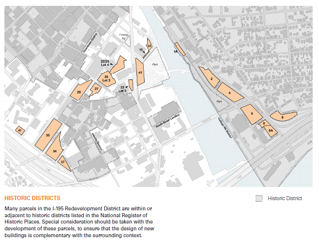
4.3 Flood Resilience Map

FLOOD RESILIENCE
Many parcels in the I-195 Redevelopment District are partially or entirely below DFE-1 as defined in Section 2.6 Flood Resilience Standards. Developers proposing on parcels with an existing grade that is partially or fully below DFE-1 should conceptualize their project in response to this increased flood risk.
4.4 Flood Resilience Resources
- EMERGING FLOOD RESILIENCE BEST PRACTICES AND DEFINITIONS
- Design Flood Elevation (DFE)
Design Flood Elevations (DFEs) are required minimum floor heights based on existing and future flood conditions. In the District, there are two DFEs: DFE-1 for the ground floor height and DFE-2 for the second floor and critical infrastructure. - NAVD88
The North American Vertical Datum of 1988 (NAVD 88) is the vertical control datum leveling network that denotes the fixed the height of the primary tidal benchmarks in North America. - Wet Floodproofing
Wet floodproofing allows water to enter and exit non-habitable portions of a building through engineered flood vents. This strategy minimizes structural damage from flood waters by equalizing hydrostatic pressure on the walls of the building, and prevents damage from buoyancy or uplift forces. In the District, wet floodproofing is allowed in low-occupancy service spaces such as loading and parking.
Engineered flood vents are part of a wet floodproofing strategy. - Dry Floodproofing
Dry floodproofing is a system of multiple components aimed at inhibiting water from entering a structure. This technique is appropriate for low flood elevations and non-residential portions of structures that can withstand hydrostatic and hydrodynamic loads imposed by flooding. Dry floodproofing strategies may include watertight enclosures for openings, including barriers that might require human intervention in advance of a storm event; membranes and sealants to reduce seepage; structural reinforcement to wall assemblies and foundations; drainage and pumping systems with backup power to control water intrusion; check valves to prevent the entrance of water or waste through plumbing systems; and flood doors and egress requirements. In the District, dry floodproofing may be allowed for lobbies or entries below DFE-1.
Deployable flood barriers are part of a dry floodproofing strategy. - Critical infrastructure
Building utility systems, including electrical and mechanical equipment that would create costly damage, safety risks, and loss of habitability and other critical building functions during a flood event are considered critical iInfrastructure.
Critical mechanical systems include:
- Boilers and furnaces;
- Air-handlers, condenser units, and heat pumps;
- Ductwork and piping;
- Fuel storage tanks;
- Water heaters;
- Fire-suppression sprinkler controls; and,
- Elevator machine rooms.
Critical electrical systems include:
- Electrical panels and switchgear;
- Backup generators;
- Alarm controls and components;
- Service wiring and receptacles;
- Building management systems;
- Telecommunications equipment;
- Electric and gas meters; and,
- Utility shut-off switches.
- Flood-Resistant Materials
Flood damage-resistant materials are any building materials, components or systems capable of withstanding direct and prolonged contact with floodwaters without sustaining significant damage. They include materials such as concrete, stone, masonry block, ceramic and clay tile, pressure-treated and naturally decay-resistant lumber, epoxy paints, and metal. In addition to resisting damage from flood waters, these materials are relatively easy to clean after flood waters have receded.
Additional Resources:
- FEMA Technical Bulletin 2: Flood Damage Resistant Materials Requirements
- Building Science Corporation, BSD-111: Flood and Hurricane Resistant Buildings
- Landscape Interventions
There are many landscape intervention strategies to improve site and district-level resilience. At a minimum, landscapes should be designed to maximize stormwater absorption, require minimal irrigation or fertilizer, and be salt-tolerant where applicable. Plant species with robust root systems will hold soil and land best, preventing severe erosion damage. Care should be taken to utilize native plant species that contribute to the greater ecosystem of which the District is a part.
Landscape interventions designed to maximize stormwater absorbtion contribute to site, district, and watershed resilience. - On-site Energy Production
In the event of a blackout, providing reliable on-site backup power for continued operation of critical services can greatly increase a building’s resilience. A backup power system includes generation equipment, dedicated circuitry, and associated components.
Examples of power generation include:
- Fuel-fired generator, with stored fuel supply;
- Piped natural gas generator;
- Bi-modal solar-electric system with battery storage;
- Combined Heat and Power, sometimes referred to as cogeneration, or “cogen,” which generates on-site electricity and utilizes waste thermal energy for heating end-uses.
Additional Resources:
- Enterprise Community Partners, Inc., Ready to Respond: Strategies for Multifamily Building Resilience
- LEED Resilient Design Pilot Credit: Passive Survivability and Back-up Power During Disruptions
- FEMA Recovery Advisory 2: Reducing Flood Effects in Critical Facilities
- Backup Water Management
Backup water management systems, including sump pumps and backflow preventers, protect buildings from unintended flood water entry in conjunction with floodproofing strategies. Sump pumps remove water from below-grade spaces. They also remove water from an underdrain system at the perimeter of below-grade walls or under a slab on grade. Sewage Backflow Prevention options include check, gate, and dual backflow valves.
Additional Resources:
- FEMA P-348, Edition 2: Protecting Utility Systems from Flood Damage
- FEMA P-348, Edition 2: Protecting Utility Systems from Flood Damage
- Design Flood Elevation (DFE)
- FLOOD RESILIENCE CONTEXT AND APPROACH
- Goals for the Guidelines
As stated in Section 2.6, the goal of flood resilience standards in the District is to balance best practices for long-term flood protection with reasonable development feasibility and public realm benefit. Flood resilience standards are specific to the District’s unique geography and hydrology, and include measures to protect new structures from both the immediate threats of riverine and tidal flooding, as well as longer-term risk associated with storm surges. The District sits in a FEMA X zone and is not subject to FEMA flood requirements, as it is protected by a hurricane barrier. Requirements set forth in this document reflect risk from existing riverine flooding events and future sea level rise, neither of which are currently accounted for in FEMA regulations. - Lifespan & Timespan
Development in the District requires design considerations for long-lifespan commercial and residential buildings. It is more efficient to elevate buildings and critical infrastructure before buildings are built. For this reason, our methodology looks out to 2100. - Data Sources
- Sea Level Rise
Due to the complex and dynamic variables that contribute to sea level rise, projections beyond 2050 are more uncertain than near-term projections. The latest NOAA sea level scenarios for Providence, RI in the year 2100 range between 1.6 feet and 6.3 feet of SLR above mean higher highwater. Our methodology designs for the NOAA Intermediate Curve of 3.74 feet of SLR.
2022 NOAA SLR projections for the year 2100 in Providence.
STORMTOOLS inundation mapping for 3’SLR and 100yr storm. - Riverine Flood Data
The highest recorded high water from a precipitation event in the Providence River was an elevation of 9.29 feet NAVD88 during the 2010 Great Floods—a series of rainstorms between February and March of that year that inundated the state with stormwater.
Source: Flood Insurance Study: Providence County, Rhode Island (All Jurisdictions). FIS Number 444007CV001C:Federal Emergency Management Agency, 2015. https://tinyurl.com/4v9rfz5k - Storm Surge
CRMC STORMTOOLS is a model to map storm inundation for varying return period storms across all of Rhode Island’s coastal waters. Predictions show water extent and depth at any given point for nuisance floods (1, 3, 5, and 10 year intervals) and 25-, 50-, 100-, and 500-year storm scenarios at a 95% confidence interval. Sea level rise of 1, 2, 3, 5, and 7 feet on its own as well as combined with each storm scenario is also modeled. Inundation levels in the District vary depending on topography and other factors, but averages 23’ for District parcels.
Source: STORMTOOLS https://stormtools-mainpage-crcuri.hub.arcgis.com/
- Sea Level Rise
- Special Consideration: Hurricane Barrier
Currently, the Fox Point Hurricane Protection Barrier closes to protect downtown Providence from storm surge events. During a storm event in which the barrier is deployed, large pumps pull water from the Providence River that would otherwise accumulate upstream of the barrier. The pumps are operated to keep the upstream water levels at or below 8.87’ NAVD88.
The barrier was built to protect from storm surges up to 20’, but was not built to withstand the level of sea level rise that we may see in 50 or more years, and the barrier does not close for regular tidal flooding events. The City of Providence and State of Rhode Island are due to make a decision by 2050 about redesigning the barrier to accommodate for both aging infrastructure and increased sea level rise that could overwhelm the barrier.
Because of the severity of worst-case scenarios identified by STORMTOOLS modeling (in the event of barrier failure during a major storm event) our methodology does include designing for this rare scenario. - Design Flood Elevations
- DFE-1
Most flood events will be due to tidal and riverine flooding, both of which are not currently mitigated by the hurricane barrier. Of these risks, riverine flooding is more immediate, higher in elevation, and less predictable.
Accordingly, the DFE-1 is set at 9.3’ NAVD88, just above the historic high river mark recorded in the Providence River due to heavy rainfall over the course of several months in 2010. This elevation provides protection for near-term worst case scenarios, as well as long-term protection from tidal flooding exacerbated by sea level rise. - DFE-2
While the hurricane barrier is anticipated to provide protection from storm surges for the near term, there remains some measure of risk associated with extreme weather events. If the barrier gates are not operable, or sea level rise in conjunction with a storm surge causes the barrier to be overtopped, flooding could be extensive. While the risk of these is either low or far in the future, it is nonetheless prudent to take measures to ensure that buildings in the District are at least resilient, if not protected, in the event of a barrier breach.
This approach allows the development parcels to assume a measure of protection by the barrier for storm surges, but encourages an additional layer of long-term resilience by requiring that critical infrastructure and building mechanical systems be placed out of harm’s way. The objective is to ensure that while some damage to the ground level may occur, the overall building and its occupancy are not completely compromised.
- DFE-1
- Goals for the Guidelines